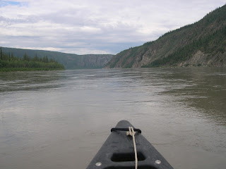
We had talked a few days ago to Colin, 'the' guy in Dawson who 'did' canoes. He thought that we should canoe down the Yukon River to 40-mile creek. In 100 times of sending people down the river, only once did anyone miss the stopping point. Taking a look at the swift moving river filled with eddies, considering the logistics and possible nightmare of missing 40 mile creek where Colin was to pick us up gave us pause, and so Richard called him Thursday night to consider our options. Perhaps canoeing down the smaller Klondike River *to* Dawson City in which case we would be unlikely to miss our destination, would be preferred? After a few more words, Richard hung up and announced that the Yukon River to 40-mile creek it would be. There would be another couple sharing the journey with us. I must say that this did alleviate some worries but I stared at the ceiling for a while the night before imagining various scenarios none of them particularly good.
At 8:30 we showed up and were given a map (which was most useful) and each canoe got a GPS, one of which (the other canoe) worked. The GPS proved to be most useful for determining the actual distance that we canoed -- in fact 40mile creek is as the crow (or raven, here) flies -- the actual distance was 48.5 miles, or about 78 km. As we prepared to launch, my stomach was churning as much as the water!
Our travelling companions were Karen and Lee, a physiotherapist and retired teacher from Wyoming. They were perfect companions, smart, funny, able, and about the same age and speed!
Here are some views from the early part of the trip.
 |
| Deceptively calm but filled with strange sub-surface disturbances. The whole thing is running at up to nine mph (measured). |
There was little white water on the trip. Just near the shores and easily missed. The main challenge fell to Richard who had to keep us from drifting sideways (or reversing) from the many eddies. The first time we stopped, I didn't realize that we were *supposed* to turn backwards in order to come up to shore.
 |
| GPS is a puzzle. |
We carried on to our lunch break point.
 |
| Judith is still strong enough to hold the camera. at high water it would be storming over us and running even faster. |
The hardest part of the journey was from lunch to Cassiar Creek -- our arms and shoulders were sore and we still had a long way to go.
We passed several isolated forest fires -- a helicopter took off in front of us, presumably checking them out.
 |
| Damned GPS. |
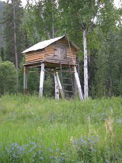
This is where the food would be put to keep it out of reach of bears.
Here is Richard -- still trying to figure out how the gps worked. Fortunately, he understood maps.
On the final stretch.. some snow still.
Made it -- 6:15 p.m. I guess the river did most of the work, but we had put in a pretty good effort too! Boy were we glad to see Colin at the appointed place. He brought along some cold beer for everyone.
40-mile Creek was a 20-minute walk from the first site at which 'coarse gold' was discovered and ended up being the first settlement in the Yukon, circa 1886? Fatigued, we took the walk while Colin meandered off to do some panning. The mosquitos, tired muscles, and concern about bears ensured that we didn't stay long.
We didn't quite realize that it was a substantial journey back to Dawson City from the pick-up point that was on the wrong side of the river from Dawson. It took us up to the 'Top of the World' highway which is the one that you can take from Dawson to Alaska. En-route, Colin made a stop to deliver some rope to a small miner's camp. This is what it looked like.
On the way back, Colin entertained us with stories. It is amazing how resourceful the locals are. We finally got the courage up to ask what happened to the one case in which the canoe-trippers missed the stopping point. This was a British couple who continued on down the river, almost to Alaska. They had one of those shiny space-blankets and a flint so could make a fire, but spent a rather scary night listening to the wolves howl and no doubt fending off mosquitos. Colin had waited for a several hours and finally talked to a boater who apparently had seen them. Eventually he contacted the natives in the areas who had been fishing salmon. The next morning the salmon fishermen shared their catch with the Brits and brought them back to 40-mile Creek for Colin to take home. In the car home, the woman turned to her husband and said, 'Perhaps we could take a tent along next time dear." I was playing out how this scenario might have unfolded down south, with 911 calls and Search and Rescue involved. Here, Search and Rescue is still available, but people are more likely to get by on their wits, their ability, their courage, and the help of each other.
The ferry back to Dawson City. We got home around 9:30 pm.


No comments:
Post a Comment